


 Рус.
Рус.  Eng.
Eng.
- Brief information about the satellite terminal SmartOne_B system Globalstar
1.1 Appoinment SmartOne_B satellite terminal
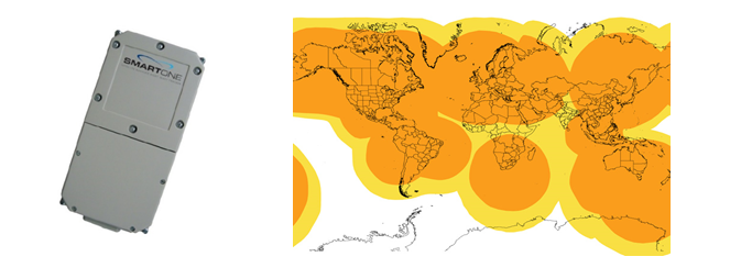
Figure 1 - The appearance of the Figure 2 - Coverage to the simplex data
terminal SmartOne_B transmission Globalstar
Satellite tracker Globalstar SmartOne_В (Fig.1) specially designed for the real-time monitoring for stationary and mobile objects and the status of selected sensors at these objects, the route of which is carried out in nook, remote and mountainous areas of Kazakhstan and other parts of the world where there are no terrestrial wireless communication channels.
Satellite tracker SmartOne_В Globalstar provides a one-way (simplex) data transfer from the object to the FMS Control Center throughout the actions of the Globalstar system (Fig.2). It has the GPS receiver to determine the time and coordinates of the tracker location and two digital inputs for connecting the necessary sensors of object.
The power tracker is carried from 4 built-in half-volt lithium battery format AA, which ensures continuous operation of the tracker from an independent power supply for over 3 years and eliminates the need for expensive rechargeable batteries. In addition, the tracker SmartOne_В can be connected to an external (onboard) power source with voltage from +10V to +48V.
Tracker SmartOne_В has a built-in antenna Globalstar and GPS, has small dimensions, which greatly facilitates its mounting on a vehicle for various purposes.
1.2 Functional features of the terminal SmartOne_B
Tracking Status Of Reports:
- awakening from sleep at a preset time, GPS location, data transfer of sensor state, resume sleep;
- set up to 12 programmable sleep intervals or time awakening from sleep;
- regular reporting in accordance with established time frames ranging from 5 min up 24 hours;
- reporting, caused by actuation of the connected sensors (2 inputs).
Configuring the working mode of the terminal and inputs:
- programming/configuration usinga laptop orPDAhandheld device;
- independently configurable: negative, positive, or any intermediate threshold;
- instanttransmission ofmessages, GPS location when the message or the specified interval
Built-in motion sensor:
- message onstart and stop motion;
- reaction to the differentialin the event of movementin timeor durationof movement.
Power supplies:
- self-powered from 4 AA lithium ion batteries 1.5 V size AA. The duration of the battery is up to 7 years battery life (2 messages /day);
- external power from onboard DC voltage from 10V to 48V.
Construction and installation
- terminal SmartOne_В has a durable sealed housing that meets the requirements of the international standard IP67.
- flat case with built-in antenna and small size (25mm*83mm *165mm) makes it easy to install this GPS tracker on any vehicle even in the absence of an external power source.
1.3 Advantages of terminal SmartOne_В
- Real-time monitoring of location, route and sensors status of mobile assets and cargo in nook and remote areas of Kazakhstan, and also other parts of the world where there are no terrestrial wireless communication channels (GSM,CDMA, Wi-Fi, Wi-Max, TETRA, etc.).
- Working in the Globalstar Simplex network and integrated GPS, these trackers are the ideal solution for operational efficiency and security.
- The presence of a vibration sensor that allows you to track the start and end of the movement of the movable assets and cargo on the route, thanks to the transmission of the report state changes to the WEB server.
- The possibility of the formation of geofences along the route of transport or cargo. At the entrance or the outlet of the movable assets from the geofence, automatically reported to the WEB server with date, time and location coordinates of the tool.
- Ability to work without external power for a long period of time (not less than 3 years when you send a report 2 times a day).
- Two digital inputs for connecting various sensors (the "Alarm" button, opening the doors, the violation of electronic seals, temperature control, etc.).
- Easy to install and get started, thanks to sealed and shock resistant housing and small size.
- Ability to work in a wide temperature range from -45C to +85C.
- Low cost terminal available for installation on containers, cars, tanks, river and sea vessels, carried bulky equipment.
2. Brief information about the satellite terminal SmartOne_С system Globalstar
Satellite tracker Globalstar SmartOne_С is a further upgrade to the above model SmartOne_B with the development and use of new technologies. The new tracker is shown in Fig.-3.
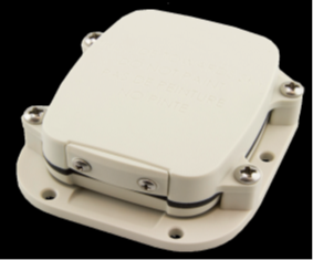
Figure 3 - Appearance tracker SmartOne_C
The main differences of the new SmartOne_С from the previous model is the following:
- Much smallerconstructive size (25mm*69mm*83mm) under the same conditions of use 4 AA batteries for Autonomous power supply. This further simplifies mounting and installationon the vehicle;
- Extended range of useof external sourcesof power supply: connection to an external power source +5V; connection to an external power source from +8V to +22V
- Significantly lighter weight terminal SmartOne_С-102 grams against the weight of the terminal SmartOne_B– 385 grams;
- Used more sophisticated and sensitive accelerometer for track start and stop of the vehicle.
3. System of Transport Monitoring with the use of the satellite system Globalstar
3.1 Assigning FMS
The Fleet Monitoring System (FMS) is a telematic system based on the use of global satellite positioning GPS facility, the global satellite communications system Globalstar in the quality of the transmission channel, and a satellite tracker installed on the vehicle carrying out the transport of cargo. In the FMS Control Center is receiving and processing data from all existing satellite trackers and providing this information to the owners of these vehicles via the Internet.
Thus, the FMS is designed to monitor real-time location, route and condition of transport and cargo during transportation on the remote and sparsely populated areas of Kazakhstan, and, if it is necessary, anywhere in the world where there are no terrestrial transmission channels. Software FMS Control Center fully developed by Kazakhstan’s company Argus Contact Ltd.
3.2 Functional characteristics of FMS.
3.2.1 Receive real-time data from existing satellite tracker of Globalstar system is carried out on the WEB-Server and the data stored in the Database of this Server (the vehicle ID, date, time of sending of the message, time of message, reason for message, location coordinates, sensor status, etc.).
3.2.2 Decrypting data received from a satellite terminal and displaying the received message on the display in the table "Current data from the objects in the main window "Tracking object".
3.2.3. Displaying in the table "Observing Object List" in the main window “Tracking Objects" of all active and registered on the server of moving objects and their status.
3.2.4. Displaying in real time the current location of mobile objects on the electronic map in the main window, the "track objects".
3.2.5. The possibility of selection by the user of various types of electronic maps of various well-known manufacturers, including satellite (Open Street Map, 2GIS, Yandex Map, Goodle Map for easy viewing and choice of scale).
3.2.6. The possibility of constructing and analyzing the movement route of the vehicle and cargo over any selected period of time.
3.2.7. Access via the Internet to a WEB server interested Customers on an established login and password to obtain information about their vehicles registered on the WEB Server.
3.3 Advantages of Fleet Monitoring System, developed by "Argus Contact" Ltd:
- WEB Server TMS is located on the territory of the Republic of Kazakhstan, has the clear and convenient interface for Customers of Kazakhstan and does not require high-speed international communication channels in case if WEB-Server was located overseas.
- Having our own System of Monitoring of Transport for the WEB-Server Ltd "Argus Contact" has the ability to improve this, the extension service capabilities of FMS taking into account the needs and interests of Kazakhstan's Customers.
- The use of a data transmission channel through SMC Globalstar, provided the mode of "on-line" for receive information about location, route, condition of sensors of the vehicle or cargo when driving in mountainous areas, navigable rivers and seas, in remote and uninhabited areas of the territory of Kazakhstan or in any part of the world where Globalstar ATP, but no ground-based communication channels (GSM,CDMA, Wi-Fi, Wi-Max, TETRA, etc.).
- The FMS may be required for use in the following industries in Kazakhstan, where difficulties may arise with the presence of an external power supply for trackers:
- on the Railways to automatically determine the location and route of railway wagons, oil and gassoline tanks;
- during the transportation of dangerous and valuable cargoes long distances by road, sea and aircraft;
- tracking the location of containers and other large-dimensional cargoes during transportation over long distances;
- tracking the location and movement exploration parties and ethno-geographical expeditions in hard-accessible and remote places of our planet.
- when making Hiking, trekking and mountain climbing in mountain areas, forests, rafting on rivers or sea trips and travel.
- Testing terminal SmartOne_B on the route Almaty – Assy plateau (Almaty region)
Before the start testing, satellite terminal SmartOne_B was tuned up on the stand for a certain mode of operation with the specified period of reporting in time. In addition, one of the inputs was connected to the "Alarm" button, When it pressed, the disturbing signal must come to the Control Center of FMS. Before movement, the terminal SmartOne_B был installed on the Nissan X-trail on the dashboard directly under the windshield as shown in Photo-1. The power of the terminal was carried out from 4 AA batteries.
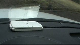
Photo 1- The location of the satellite tracker in the car
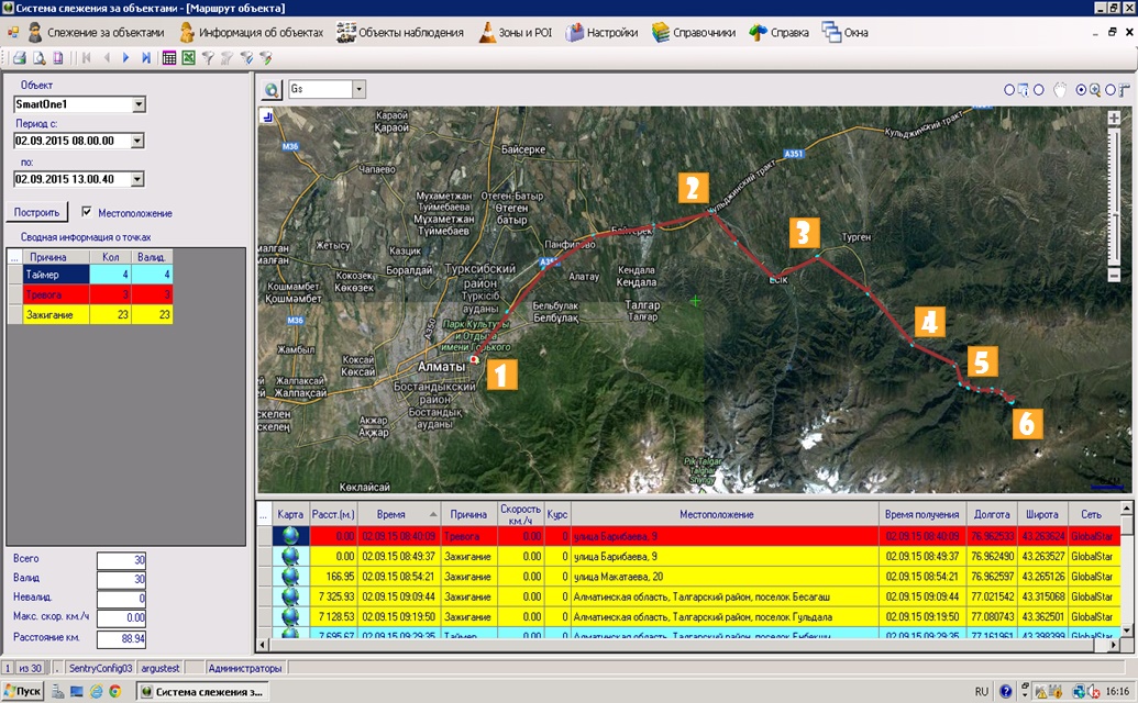
Figure 4 - PrtSc of a computer screen displaying the vehicle route received at the Fleet Monitoring System of Argus Contact Ltd, obtained in the mode of "on-line" from the terminal SmartOne_B satellite mobile communication Globalstar with indicating the points where the pictures were taken.
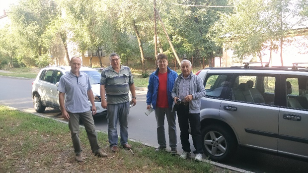
Photo 2 - The participants of the testing terminal SmartOne_В satellite communication Globalstar in the beginning of the route (point 1) in Almaty
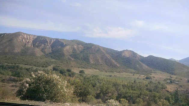
Photo 3 - View of the area at point 2 after the turn in the Turgen canyon

Photo 4 - View of the area at point 3 after the turn in the Turgen canyon
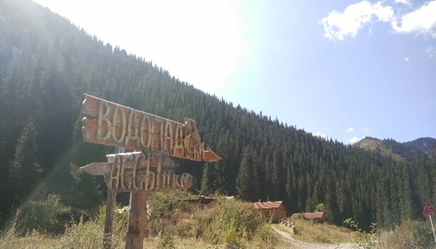
Photo 5 - View of the area at point 4. Start lifting at Assy plateau
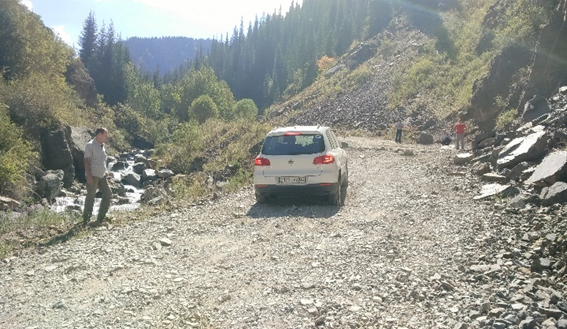
Photo 6 - View of the area at point 4 of the route during the ascent to the Assy plateau
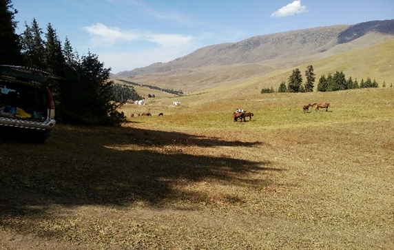
Photo 7 - View of the area at the endpoint of route 5. Assy plateau
- Test terminal SmartOne_C on the route Almaty – Assy plateau (Almaty region)
Before the start testing, satellite terminal SmartOne_C also was tuned up on the stand for a certain mode of operation with the given transmission period of the report in time. During the testing, terminal SmartOne_C was installed inside of the other car Volkswagen Tiguan on the front panel under the windshield.
The route of the VW Tiguan with the terminal Smart One C on the route Almaty – Assy plateau, 02.09.2015 shown in Fig.5.
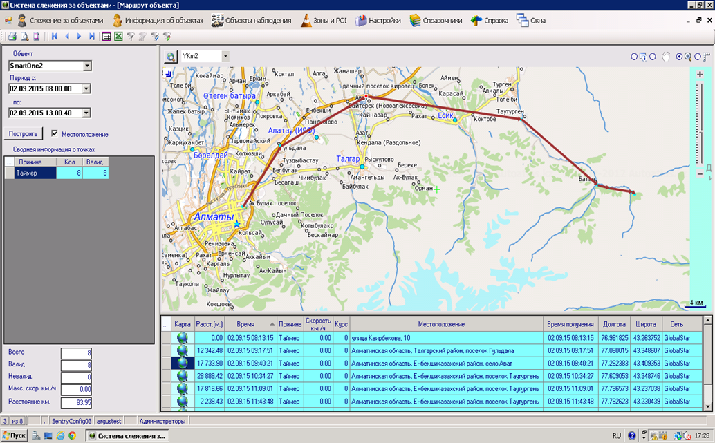
Figure 5 – PrtSc screen Fleet Monitoring system display the route of the VW Tiguan, obtained using SmartOne_С
For clarity in the Fleet Monitoring System it was choosed another e-map of the company Autoatlas, which is available on our WEB-server. This map is more detailed and with a large number of settlements. This map reflects the route of the vehicle for the time period from 08 hours 00 minutes 02 Sep 2015 to 13 hours 00 min 02 Sep 2015.
On the mode of self-contained supply terminal SmartOne_С worked reliably on the all route Almaty-Assy plateau. To save the cost of the traffic, the terminal was installed interval timer reporting -35 min. In this regard, the number of counts on the route were not sufficient to determine the real traveled distance. On other characteristics the terminal no comments.
- The route to the Test terminal in Almaty SmartOne_B – pension Altyn Kum (lake Issyk-Kul, Kyrgyzstan)
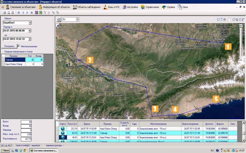
Figure 6 - PrtSc from a computer screen displaying the route of the vehicle received in the Fleet Monitoring System of Argus Contact Ltd obtained in the mode of "on-line" terminal SmartOne_B satellite mobile communications Globalstar with indicating the points where the pictures were taken.

Photo 8 - View of the area at point 1 at the beginning of the route in Almaty.
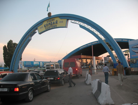
Photo 9 - Point 2on the routeof the vehiclein FMS.Customs poston the borderKazakhstan-Kyrgyzstan
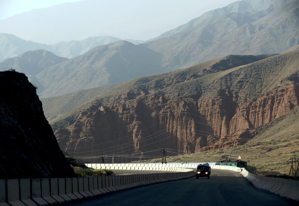
Photo 10 - Point 3 on the vehicle route in Boom canyon on the road to Issyk-Kul (Kyrgyzstan)

Photo 11 - Views of the lake Issyk-Kul in point 4 of the route
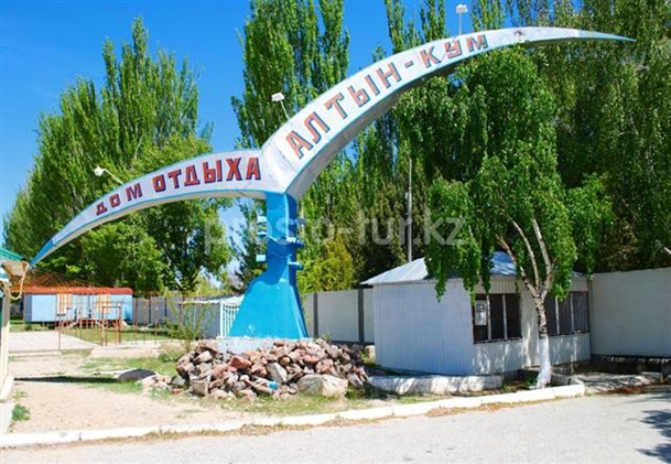
Photo 12 - End point 5 of the vehicle route, the pencion house Altyn Kum
- Conclusions the results of testing of satellite trackers SmartOne_B and SmartOne_С.
The sensitivity of GPS receivers at both terminals SmartOne_В and SmartOne_C is high enough to install the terminals inside the cabin of the car radio transparent place.
Self-contained power supply these terminals from 4 penlight AA batteries, allows to ensure the normal operation of the trackers for a long time from several months to several years depending on the frequency of reporting. There is no need to purchase costly batteries to replace.
Satellite terminals SmartOne of the system Globalstar is work well as in urban conditions (conditions of high level radiation and high-rise) and also in mountain conditions (with limited review of the horizon).
Terminal SmartOne_C has smaller dimensions and more features and characteristics in comparison with SmartOne_В and can be recommended for widespread use in monitoring of mobile objects and goods.
SmartOne satellite tracker of the Globalstar systemis preferable to use, when important value has the absence of ground communication channels and there areserious limitations in the provision of external power supply.
Ltd "Argus Contact" successfully integrated SmartOne terminals in its own System of Monitoring of Transport and provides control and data processing basic functionality of these terminals to provide future Clients in Kazakhstan of monitoring services, transport and goods almost anywhere in the world.
Director of the Ltd "Argus Contact": Akhmetov Zh.K.